


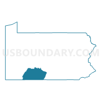
Somerset, Bedford & Fulton Counties PUMA, Pennsylvania
About
Outline

Summary
| Unique Area Identifier | 193917 |
| Name | Somerset, Bedford & Fulton Counties PUMA |
| State | Pennsylvania |
| Area (square miles) | 2,535.89 |
| Land Area (square miles) | 2,524.22 |
| Water Area (square miles) | 11.67 |
| % of Land Area | 99.54 |
| % of Water Area | 0.46 |
| Latitude of the Internal Point | 39.97825260 |
| Longtitude of the Internal Point | -78.64961770 |
Maps

Graphs
Select a template below for downloading or customizing gragh for Somerset, Bedford & Fulton Counties PUMA, Pennsylvania


Neighbors
Neighoring Public Use Microdata Area (by Name) Neighboring Public Use Microdata Area on the Map
- Allegany & Garrett Counties--Cumberland City PUMA, MD
- Blair & Huntingdon Counties--Altoona City PUMA, PA
- Cambria County PUMA, PA
- Fayette County PUMA, PA
- Franklin County (Outside Washington Township & Waynesboro Borough) PUMA, PA
- Washington County--Hagerstown City PUMA, MD
- Westmoreland County (East) PUMA, PA
Top 10 Neighboring County (by Population) Neighboring County on the Map
- Westmoreland County, PA (365,169)
- Franklin County, PA (149,618)
- Washington County, MD (147,430)
- Cambria County, PA (143,679)
- Fayette County, PA (136,606)
- Blair County, PA (127,089)
- Somerset County, PA (77,742)
- Allegany County, MD (75,087)
- Bedford County, PA (49,762)
- Huntingdon County, PA (45,913)
Top 10 Neighboring County Subdivision (by Population) Neighboring County Subdivision on the Map
- Richland township, Cambria County, PA (12,814)
- Somerset township, Somerset County, PA (12,122)
- Conemaugh township, Somerset County, PA (7,279)
- Ligonier township, Westmoreland County, PA (6,603)
- Somerset borough, Somerset County, PA (6,277)
- Adams township, Cambria County, PA (5,972)
- Upper Yoder township, Cambria County, PA (5,449)
- Bedford township, Bedford County, PA (5,395)
- Peters township, Franklin County, PA (4,430)
- Greenfield township, Blair County, PA (4,173)
Top 10 Neighboring Place (by Population) Neighboring Place on the Map
- Somerset borough, PA (6,277)
- Windber borough, PA (4,138)
- Elim CDP, PA (3,727)
- Bedford borough, PA (2,841)
- Belmont CDP, PA (2,784)
- Meyersdale borough, PA (2,184)
- Berlin borough, PA (2,104)
- Everett borough, PA (1,834)
- Claysburg CDP, PA (1,625)
- Friedens CDP, PA (1,523)
Top 10 Neighboring Unified School District (by Population) Neighboring Unified School District on the Map
- Washington County Public Schools, MD (147,430)
- Allegany County Public Schools, MD (75,087)
- Connellsville Area School District, PA (34,494)
- Garrett County Public Schools, MD (30,097)
- Greater Johnstown School District, PA (27,676)
- Uniontown Area School District, PA (23,820)
- Somerset Area School District, PA (21,327)
- Tuscarora School District, PA (18,407)
- Mount Pleasant Area School District, PA (17,888)
- Bedford Area School District, PA (16,838)
Top 10 Neighboring State Legislative District Lower Chamber (by Population) Neighboring State Legislative District Lower Chamber on the Map
- State House District 90, PA (70,210)
- State House District 86, PA (66,211)
- State House District 80, PA (62,593)
- State House District 59, PA (61,834)
- State House District 78, PA (60,809)
- State House District 81, PA (60,600)
- State House District 69, PA (58,411)
- State House District 72, PA (58,097)
- State House District 51, PA (56,731)
- State House District 73, PA (56,680)
Top 10 Neighboring State Legislative District Upper Chamber (by Population) Neighboring State Legislative District Upper Chamber on the Map
- State Senate District 33, PA (280,954)
- State Senate District 30, PA (239,492)
- State Senate District 41, PA (236,058)
- State Senate District 35, PA (232,251)
- State Senate District 32, PA (225,580)
- State Senate District 1, MD (118,930)
Top 10 Neighboring 111th Congressional District (by Population) Neighboring 111th Congressional District on the Map
- Congressional District 6, MD (738,943)
- Congressional District 9, PA (666,810)
- Congressional District 18, PA (653,385)
- Congressional District 12, PA (612,384)
Top 10 Neighboring Census Tract (by Population) Neighboring Census Tract on the Map
- Census Tract 2605, Fayette County, PA (6,519)
- Census Tract 116, Franklin County, PA (6,485)
- Census Tract 208, Somerset County, PA (6,230)
- Census Tract 206, Somerset County, PA (6,094)
- Census Tract 115, Franklin County, PA (5,991)
- Census Tract 133, Cambria County, PA (5,972)
- Census Tract 113, Blair County, PA (5,938)
- Census Tract 115, Blair County, PA (5,923)
- Census Tract 209, Somerset County, PA (5,892)
- Census Tract 9610, Bedford County, PA (5,779)
Top 10 Neighboring 5-Digit ZIP Code Tabulation Area (by Population) Neighboring 5-Digit ZIP Code Tabulation Area on the Map
- 21502, MD (44,400)
- 15905, PA (21,226)
- 15501, PA (16,861)
- 15904, PA (16,608)
- 21532, MD (15,620)
- 15522, PA (12,036)
- 15963, PA (11,114)
- 15658, PA (8,916)
- 17236, PA (8,895)
- 15537, PA (7,952)